Powered By Blogger

Friday, January 14, 2011

P E R U

The Republic of Peru is the third largest country in South America, after Brazil and Argentina.  The capital is Lima.  The main official language is Spanish, which is spoken by 80% of the population.  Other official language is Quechua, spoken by 16% of the population, mainly Inca descendants.
It can be said that Peru is a country of extremes. It boasts a lot of the world's highest mountains, the world's driest desert, the world's most biologically diverse rain forest, the world's richest fishery, and the world's most extraordinary cultural and archeological diversity.  The most extraordinary ancient stone architecture in the world is in Peru.  The most extensive pre-Columbian empire in the New World revolved around the imperial capital of Cuzco.   The deepest canyon in the world is in the southern Andes of Peru.  The world's greatest varieties of cultivars and cuisine are found in Peru.  Corn, potatoes, beans, chocolate, hot peppers, peanuts, pumpkins, squashes, quinoa, amaranths, and dozens of other tubers, grains and fruits are native to and were first grown in Peru. Peru has over 1700 bird species -more than any other country in the world, of which 114 are unique to Peru.  More species of tress (300) are found in 2.5 acres of rain forest in northeastern Peru than in any other place in the Earth.
There have been people inhabiting this land for approximately 10,000 years.  The Incas came around 1500 AD, and were possibly the most organized civilization in South America.  Their economic system, distribution of wealth, artistic manifestations and architecture greatly impressed the first of the Spanish chroniclers.
The Inca worshiped the earth goddess Pachamama, and the sun god, the Inti.  The legend of the origin of the Incas tells how the sun god emerged from the waters of Lake Titicaca and sent his children Manco Capac and Mama Oclio to found a sacred city at the "navel of the world", which was to be named Cosco and become the capital of the Inca Empire.
The rapid expansion of the Inca domain stemmed from their extraordinary organizational skills.  The vast territory of this magnificent civilization covered the country of Peru, part of what is modern-day Colombia to the north, Chile and Argentina to the south and all of Ecuador an Bolivia, with a population calculated at more than three million people.  
In spite of this grandiosity, the imposing Inca Empire lasted only a few decades.  The fall of it may be attributed to two factors.  First, Atahualpa, the actual ruler, had been attacked by his step brother, thus dividing the empire in two groups at war with each other.  The other component was the ancient and deep belief of all the Incas in the coming of a messiah or god, who had light features and was coming mounted on a huge animal.
When Francisco Pizarro crossed the Andes in 1532, found a multitude of worshipers kneeling at his presence.  The Spanish troop of only 18 soldiers captured Atahualpa and triumphantly entered Cuzco shortly afterwards.
Peru was declared an Independent Nation in 1821 and in 1824 Simon Bolivar put an end to the War of Independence.  But the young republic faced tough economic crisis and was governed for many years by military strongmen who gave civilians little chance to govern.  It was not until 1860 that the first civilian president, Manuel Pardo, was elected.
Lima, the capital, is an attractive modern metropolis with very heavy traffic.  Being on the coast, the humidity is extremely high, although it rarely rains.  The center of the city is of a distinct architecture and is always full of tourists.  It is recommended not to visit it at night.  Outside of the center area, the streets teem with mansions, modern high-rises, excellent parks and exuberant gardens.  Banks, businesses, restaurants and night clubs are abundant in the neighborhoods of Miraflores, Barranco and San Isidro.
Cuzco is situated across the Andes from Lima and the only way to get there is by plane.  It has an altitude of 11,470 feet above the sea level, which is the cause of soroche (high altitude sickness).  It is a city where the past and the present collide in a striking mix. This mystical capital of the Inca Empire preserves with pride its walls and battlements of stone, on top of which the Spaniards built their colonial churches and mansions.  All the roofs are uniformly made of red adobe and the cobblestone, windy streets  are intriguing and charming.  It is the archeological capital of Peru and the world, surrounded by impressive remains of the glorious past, such as the temple of Qorikancha, the citadel of Machu Pichu, the Fortress of Saqsaywaman, the Pisac temple and the Ollantaytambo compound, just to mention the important ones.
Puno is the city adjacent to Lake Titicaca, the highest navigable lake in the world at 12,500 feet above sea level.  The lake is full of    floating islands made of totora reefs, which grow wildly in the lake. The Uros people  have been living there for thousands of years. The last of them died a few years ago, but they had mixed with the Aymara tribe, which had followed the same custom. Their houses and picturesque boats are also made of totora, a fiber tuber that is also edible.
These are some of the interesting memoirs of our trip to Peru in 2005.

Monday, January 3, 2011

I AM A SOFA

AUTHOR'S NOTE:  Back in the 60's, Reader's Digest used to publish a series of articles about the history of typical household items, detailing when it was invented, the way it was manufactured, its many uses, etc.  All from that item's point of view.  I remember one titled "I am a coffee mug" which was captivating because you could learn its origin, the materials that it was made of and other particulars.  And the amusing part...the mug was the biographer!
I will attempt to write my own story with the hope that you will find it interesting.  Thanks for reading it.
The sofa.


"I AM A SOFA.


I was born in the small city of High Point, North Carolina, just a couple of years ago.  I don't know the exact date but I know that it took more than 300 hours to conceive me!  Many husky men took turns to create the beautiful baby than I am today.  The first man in my life, Willy, started to form my frame using some kiln-dried maple wood from my state, which was free of knots, bark or any defects (the wood, not the state).
The ends of the many wooden parts were clean-cut, fitted double doweled and glued together and reinforced with corner braces.  In some places even screws were used. This part was a little painful (not to mention embarrassing). Then another man installed a series of tempered steel springs on my seat area.  I fell very strong at this point and knew that I could be able to resist any future heavy weights.
Then somebody else put a lot of padding on top of it and in the arm rest and sides made from animal hair.  I think it was hog or horse; I couldn't tell the difference, all I know is that it didn't smell very well.  This padding was interwoven with strips of jute, a kind of burlap made in India.  Then the whole padding was covered with synthetic fibers and polyurethane foam.
I was moved to another room then for the fancy dressing up, to get ready for my triumphant entrance into the luxurious furniture world.  A blend of cotton-polyester fabric was chosen on my favorite color: burgundy.  Every single piece was measured and recorded in a cutting list.  The many panels were plotted in chalk so they would match wherever their seams would meet when finally applied.  The largest piece covered my seat, then the back and sides were taken care of.  All these pieces were carefully straightened and secured.  Then I was turned upside down (not a very pleasant position) and my bottom was covered with a material called cambric, which does the nasty job of dust covering.  Finally, the four wooden mocha-stained legs were attached.
And presto!...I was a sofa!  When I had a chance to look myself in the mirror, I blushed with excitement.  Nobody noticed my blushing because of my deep red color; but I felt very proud and ecstatic with my gorgeous figure. My plush velvety burgundy coat covering my curvaceous and sleek body was the envy of every sofa in the huge plant.  I was sure then that I was destined to make somebody very, very happy.
After my photograph appeared in a Crate&Barrel catalog, a couple from San Antonio, Allen and Aixa, fell in love with me and soon I arrived at their home in Shady Oaks.  I also fell in love with them and specially with their two lovely princesses, Aleina and Ailani.  I soon found out that these doctors were a bunch of wild adventurers.  One day, with the help of their respective parents, Jay, Bruni, Bob and Ful, they hauled me on top of a pick-up truck and took me on a two-hour trip to a rustic cabin near the picturesque (?) town of Utopia and placed me in the living room.  Next morning, I was back in the truck for a ride to Lost Maples Park, where they proceeded to carry me for miles around the site, with the sole purpose of using me as a prop for family portraits.  At one point, the park warden stopped his vehicle to watch what we were doing.  He claimed that it was the first time that he had seen anything so crazy.  Well, that is his opinion.  Anahi and Edgar, the professional photographers, took dozens of beautiful shots; so it was hard  to choose the best ones.  Click on the entry above this article to watch some of the photos.
I hope that now that I am back home I can rest for a while.  Or they may use me for some kinky stuff in the near future.
...But that will be another story."

Saturday, August 7, 2010

DEAR READERS

I started this blog about six months ago and have written 36 articles, most of them accompanied by lots of photographs. So far, the site has received more than 400 hits and I want to express my deepest gratitude for the interest that you have shown.
But...who are you?  I don't really have a way to know.  So, this is what I'd like you to do.
Everytime that you read any of my posts, please click at the bottom of it where it says "O Comments".  A box will appear and on it you can write anything that you want (criticize my article, correct my grammar or ask any questions) and write your name (and e-mail if you wish).  This way I can add your name to my Last Will and Testament. That's how much I'll appreciate it.  THANKS.

Wednesday, July 28, 2010

TRIP TO PANAMA

PANAMA or, better said, the REPUBLIC OF PANAMA, is the southernmost country of Central America and, in turn, North America.  It borders Costa Rica to the northwest, Colombia to the southeast, the Caribbean Sea to the north and the Pacific Ocean to the south.  The capital is Panama City.  The official currency is the Balboa, which now consists only of coins with the same size and value of the American coins.  All the bills are US dollars.
The Spaniard Vasco Núñez de Balboa was the first one to arrive at the Atlantic side of the isthmus and walk the 50 miles to the south and see, for the first time, the Pacific Ocean. 
Panama was part of the Spanish Empire for 300 years (1538/1821).  The first settlement in Panama was totally burned and destroyed by the pirate Francis  Drake.  The site was then moved to another location less vulnerable to the constant attacks from the pirates.  The first settlement is now known as Panama Vieja, the second as Casco Antiguo and the modern site is called Panama City.
In the first eighty years following independence from Spain, The Panama Canal is, of course, the main tourist attraction in the country.  This astonishing engineering feat, recently named one of the seven wonders of the modern world, is really something that has to be seen to admire its magical attraction.
Bruni and I spent a fabulous week in Panama, from July 17 to the 27th. of July of 2010.  The first thing that attracts your attention on the ride from the airport is the amount of modern tall buildings and so many others (more than a hundred) now under construction. 
After breakfast on Sunday, they took us to Panama Viejo.  Only a few scattered ruins remain of what was once a beautiful town.  We visited the ruins of the cathedral and the four-story tower, where a new spiral stairway was built to allow visitors to climb to the top and enjoy the fantastic view.
We then visited the Miraflores Locks and the Canal Museum.  This was our first sight of the astonishing canal and the view of it leaves anyone perplexed in awe with this incredible engineering marvel.  Monday morning we visited the towns of Portobello and Colón.  Portobello is the oldest on the Caribbean side and it is a pity that it is not well kept, for it has some interesting sites.  First, it is the cathedral which boasts an image of "the Black Christ", a statue with a singular story.  The fort by the bay is big but also in need of better maintenance. 
Colón is the biggest disappointing town.  It is the second largest Free Trade Zone in the world, with hundreds of storage buildings.  It houses 1,750 merchants and receives more than 250,000 visitors a year from all over the world.  But the crime rate is the biggest in all of Panama. Hotels, nice neighborhoods and the Trade Zone itself are surrounded by tall walls or barbed wire.   After lunch there, we were treated to a fashion show by some local beauties.
Our hotel for tonight, the Radisson, is in the middle of a rain forest.  This hotel opened just a few months ago and it was the most beautiful of all of them.  After dinner, we again enjoyed a fantastic dancing group. 
The third day, Tuesday, we experienced the best adventure.  We embarked on a small vessel that took us from the Gatun Lake in Gamboa, through the Pedro Miguel and Miraflores locks.  We also crossed the Continental Divide.  At one point, while the chamber was at the lowest level of water, we were able to touch the concrete wall of the canal.  This fascinating journey took about four hours and was an exciting and unforgettable event.  Definitely the highlight of the whole trip.
Early morning on Wednesday, we  crossed the Chagres River to visit an indigenous village.  We were welcomed by the Embera Indians with a typical musical group.  The men dress with "taparrabos", a small strip of fabric covering their essentials; the girls are usually naked from the waist up but cover their breasts with a beautiful embroidered chest cover adorned with silver coins, in order to entertain us with their dances.  There were about 10 children that skipped school that day to meet us...and make some money. They were also dressed in their skimpy attires, very clean and extrremely courteous, offering hibiscus flowers to all the ladies present. 
After this unforgettable experience, we headed for a two day stay at the all-inclusive Playa Blanca Resort to relax and enjoy the beach, the pools and the splendid buffets.  We found out that a plastic bag in our closet was to collect the humidity from the room.  It was full with about a cup of water that had been extracted in just one day.  All in all, Panama is the most humid place that we have ever visited. 
On Thursday morning, we visited picturesque El Valle, a town situated in the crater of a dormant volcano.  The small zoo there, called "Níspero", was started with the wild animals that used to belong to dictator Manuel Noriega.
On Friday, we left our beach resort and drove on the famous Pan-American Road, which starts here in Panama and goes all the way to Canada, crossing the Bridge of the Americas on our way to Panama City. We stopped at Amador Island, where we had a very appetizing seafood lunch at an elegant restaurant overlooking the bay and the skyline of Panama City.
Saturday morning, our last day in Panama, we visited a Bird Sanctuary and another Zoo which was located inside a vast Botanical Garden that was very interesting.  The biggest attraction there was a Harp Eagle, the national bird of Panama.
The farewell dinner was full of surprises.  First, it was at the private room in the Miraflores Lock observatory building.  The food was exquisite and then Gerardo, our tour director, startled us with a fantastic show, the best of them all: a dancing group of four Panamanian girls dressed in "polleras", the typical attire, and four men that were masters of the "zapateo".   The group was accompanied by a troupe of five musicians.  A really spectacular way to finish our Panama Adventure!

Wednesday, June 30, 2010

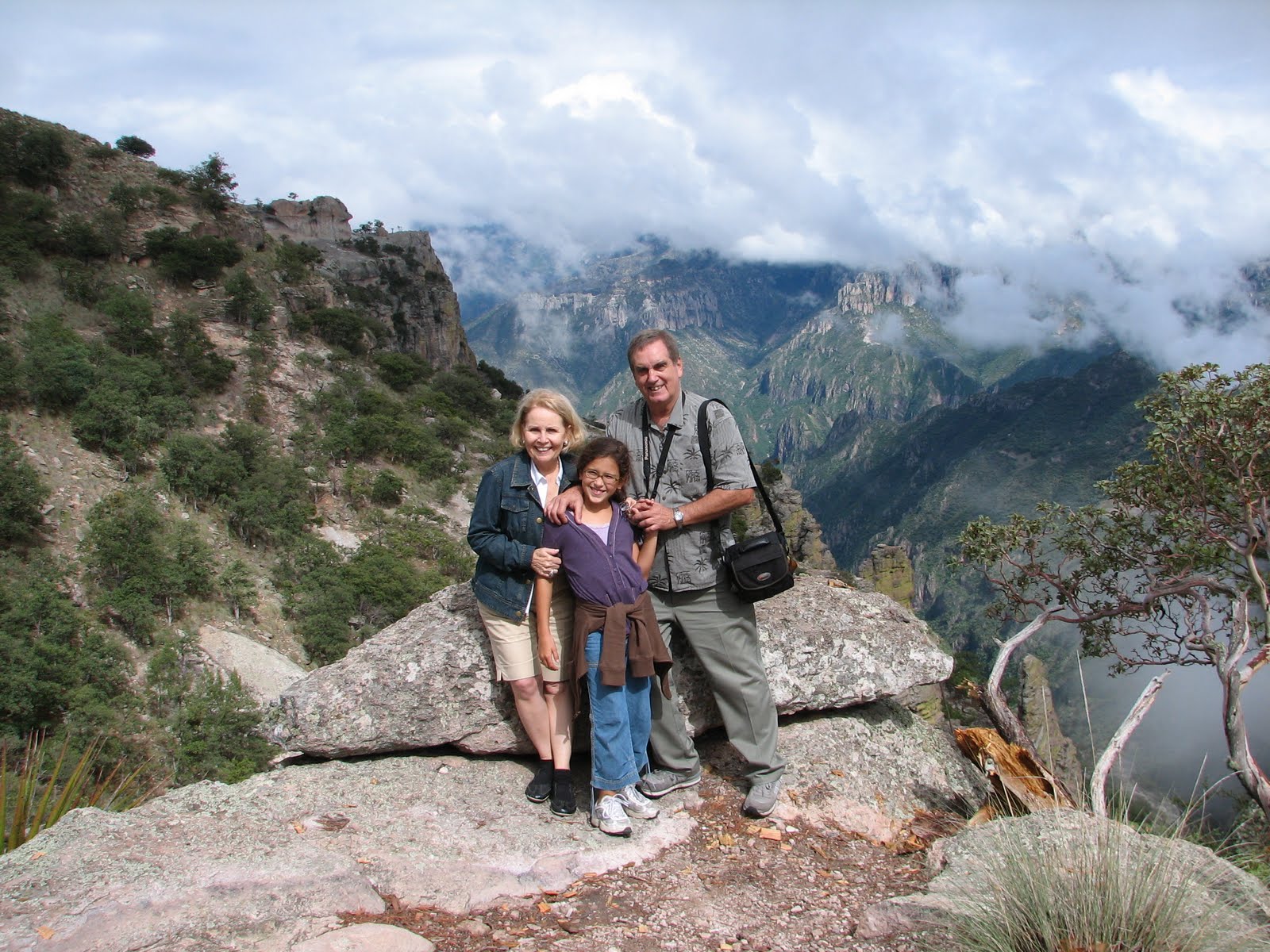
COPPER CANYON, MEXICO

Mexico is a land of colorful contrasts. From golden sand beaches to snow peak volcanoes, from blue lakes to dark green mountains.  There are many modern cities and poor little towns; extremely rich people living in lush mansions and Indian tribes barely subsisting in the countryside. Its traditions, music,  culture, art and craftmaship have fascinated tourists for centuries. 

Barrancas del Cobre (Copper Canyon) is a unique area, located in the Tarahumara Mountains of Northwest Mexico.  It takes two and a half days from Brownsville, TX, to arrive at the famous canyon, but it is worth the effort.
Alison, our 10-year-old granddaughter, accompanied us. We booked the trip with GO WITH JO, a travel agency from Harlingen.  The road passes through very interesting landscapes, starting with the Chihuahua desert, the largest in North America, with approximately 145,000 square miles.  For many years this was a typical desert, very dry and almost barren of any kind of vegetation; but in the last couple of years it has received a lot of rain and now you can see big areas covered with recent rain water and heavy brush, such as agave, creosote bush, lechugilla, mesquite, prickly pear, yuccca and sotol.  This last plant is used by the natives to produce a light beer.  The fauna has also improved dramatically and now you can find, besides snakes and mice, rabbits, frogs, road runners, deer and other animals.
Our first stop was in Chihuahua, where we visited the Government Palace, which occupies a whole block. It has beautiful murals, one of them depicting the firing by squad of father Hidalgo, the founder of the Mexican revolution, an event that happened right there in the city of Chihuahua.
The colobnial cathedral has very intricate stone walls outside.  The huge wooden doors show the passage of time and make them unique.
The next morning we boarded El Chepe, the famous train that goes from Chihuahua to El Mochis, near the Pacific coast.  This train, labeled "the world's most scenic railroad", is indeed a spectacular ride.  This engineering marvel took 90 years and 90 million dollars to complete.  It is over 390 miles long and crosses 39 bridges and 86 tunnels. We took it for just half of the length, to the town of Divisadero, our destination.
It was raining heavily when we arrived there and we had to run to our hotel, a charming example of rustic architecture.  The entrance door is carved with the figure of a Tarahumara woman.  Our room is located in a two-story building, right at the edge of the canyon. We inmediately opened the patio door but were disappointed because we just could see the heavy fog that had developed after the rain.  
The area known as the Copper Canyon is actually a series of 20 canyons, formed over the years by six rivers.  It is at least seven times the size of Arizona's Gran Canyon!
Right outside the main entrance door of the hotel there is a small Indian market, attended only by women.  These Tarahumara women are fantastic basket weavers and their merchandise is very inexpensive.  Most of them are working while carrying their babies wrapped in a blanket in their backs.  They talk very little and usually don't like to negotiate the prices.  I felt ashamed when one of our travel companions complained about this custom.  Considering the low price and fact that these poor people need a couple of dollars much more than we do, I never haggled with  them about the price.
In the afternoon, the view of the canyon from our appartment was astonishing.
After a delicious breakfast the following morning, we walked about one mile to see a Tarahumara dwelling, which consisted of a cave with a rudimentary stone wall.  There was a spring nearby and the water looked pretty dirty.  Our guide explained to us that the natives drink it without a problem but if any of us dared to taste it we would probably get sick.  There is a great mortality rate among the Tarahumara children.  The adults also live a short spam of years and when a husband dies, their house is destroyed and his wife and children have to move to another place.  Another curious custom is that after a person dies, he is never referred to by his name, but by a reference, like "the one with brown eyes" or "the one that had a fat belly", etc.
Most of the Indian women and children that we encountered spoke fluent Spanish, besides their own dialect.  They are courteous and talk very low, and they don't like to be photographed without their permission, unless you buy something from them.
After lunch, we visited a little Indian town with its own  Catholic church.  There was another market there and I bought a beautiful face mask made  out of different stones.  We also bought a delicate basket that was double-walled, so the inside is different from the outside.  We also watched a show in open air of some Tarahumara men singing, dancing and playing a guitar and a home-made violin. They also performed a race, running and kicking a wooden ball.
Then we walked a short distance to the most visited spot of the area, the balancing rock.  It is a big rock (about six by ten feet) that rocks with your movements when you stand on top .  After our guide stepped on it and started to balance it, nobody wanted to climb it, since it is a fall of more than 2,000 feet to the bottom.  I  had to prove my Cuban macho way -over the objection of my wife- and then Alison said that she wanted to do it also.  She did it with the help of our guide, never showing any sign of fear, very proud to be an Alvarez.  After that, she was nicknamed "la chiva" (the goat).
Alison was dying to ride a horse and we went with a guide to the highest peak in the area, about 7,800 feet high, from where we could see our hotel below us and the bottom of the canyon way, way down.
It started to rain and we could hear some thunder in the distance.  I was afraid that the horses could startle and throw Alison out of her mount, but she proved to be an expert rider, even though it was her first time.
On our return trip we stopped at the little town of Creel, named after the engineer that started the construction of the railroad.  We arrived back in Chihuahua in the early afternoon and visited the Museum of Pancho Villa.  Born Doroteo Arango Arámbula in San Juan del Río, Durango, in the year 1877, Villa is remembered as both a bandit and a revolutionary hero.  He is memorialized with pride along the northern states.  The museum is located in the house were he lived with his latest wife.  It also exhibits the bullet riddled car where he was riding when he was assassinated on his way to his house in Parral, Coahuila, on July 23, 1923.
We stopped at a rustic Mennonite restaurant where we had the most delicious meal of the whole trip and also made a stop at a cheese factory near the city of Cuauhtemoc, also run by the Mennonites.
After that, we visited Casa Madero Winery in Parra, Coahuila, the oldest winery in the northern hemisphere.  Because of this last stop, which was not in the itinerary, we arrived four hours late to our designated hotel, which was probably the most interesting of them all.  Rincón del Montero is a hotel that consists of several buildings in about 200 acres of land. Ali and I were looking forward to this place so we could ride horses again, but by the time we arrived there the stables were already closed.
We stopped in Parra again next morning to visit the Nuestra Señora del Madero church, which is located at the top of a hill.
Our next obligatory stop was at Saltillo to buy pan de pulque, a sweet bread that is spiced with pulque, the poor people's Mexican beer.
We arrived at the border under very heavy rain.  The streets were flooded and the line of cars to cross the bridge was long and slow.  Nevertheless, we were ordered to take all our belongings from the bus and walk under the rain until we entered the building where an Immigration officer asked just a couple of questions and we were then able to board the bus at the other side of the building.
I think that Alison will never forget this adventure as long as she lives and Bruni and I really enjoyed her company and her innocent way of doing things.  She made friends with a big dog that was always roaming around along the Divisadero hotel and when we boarded the bus there the dog accompanied her to the last minute.  It they had let her, she would have taken him with her.
This was our bonding trip with our beautiful granddaughter.

Friday, May 21, 2010

TEXAS WILDFLOWERS

After an unusually long and cold winter, the heavy rains came down in record-breaking abundance.  So, spring showed its glorious beauty in a profusion of color along the Texas roads.  By clicking on the photo section above, you can enjoy some views of this extravagant demonstration of Nature's magic.  These photographs were taken during April and June of 2010 along a few expressways, mainly 77, 35 and 37.  The best spot was on the northbound lane of Highway 37, between Natalia and Devine, just 30 miles south of San Antonio.
Every spring the roadside of most of Texas highways display a variety of different wildflowers. First come the Indian paintbrush, then the bluebonnets (the national flower of Texas) then dozens of different flowers in all sizes and colors, with just one common denominator, the exuberant abundance of them.  It is a show that have to be seen to believe it.
It all started with the ambition of a dedicated woman, Lady Bird Johnson, wife of  President Lyndon Johnson.  After his term was over and they moved back to Texas, she commenced with the beautification of Austin, the capital.  All the parks and gardens received a long-needed restoration, and thousands of flowers were planted to achieve her purpose.  In 1969 Mrs. Johnson founded the Texas Highway Beautification Awards, and millions of wildflowers seeds were scattered along the roadsides.  For the next twenty years, she hosted the annual awards ceremonies and presented her personal checks to the winners.
As the flowers die and the seeds are spread around by the winds, the increment for the next spring is guaranteed.  Because of the heavy rains, this year spring manifestation was spectacular. 
Maybe next year it will be even better.

Tuesday, May 11, 2010

CHIAPAS, MEXICO

CHIAPAS is Mexico's southernmost state.  It borders the Pacific Ocean in the south and Guatemala in the east.   The vegetation varies from tropical savanna to rain forest.  Most of the state's inhabitants are mestizos, but one third are pure Indians.  There are more than thirty Indian tribes, all speaking a different dialect, but they use Spanish to communicate between themselves.
Chiapas has little industry but is second only to Veracruz among Mexican states in value of agricultural output, producing more coffee, cacao and bananas than any other state.  The river Grijalva, flowing across the center of the state, generates more electricity at several huge dams than any other river in Mexico.  One third of this electricity is exported to Guatemala, Honduras and Belize.  It is inconceivable that in this electricity and water rich state, half the homes have neither electricity nor running water.  Rates of illiteracy and infant mortality are the highest in Mexico as well.
HISTORY: Chiapas has always been intimately connected with Guatemala. Pre-Hispanic civilizations flourished in what is now the Chiapas-Guatemala border, and for most of the Spanish colonial era Chiapas was governed from Guatemala.
During the classic Maya era (approximately 250 to 900 AD) the jungle-covered Chiapas gave rise to splendid Maya city-states, such as Palenque, Yaxchilán, Bonampak and Toniná.
Central Chiapas was brought under Spanish control by the 1528 expedition of Diego de Mazariegos, who defeated the dominant, warlike Chiapa people. The Spaniards, though, could never gain control over the scattered inhabitants of the Lacandón Jungle.
In 1821, newly independent Mexico annexed Spain's former Central American provinces (including Chiapas) but the United Provinces of Central America declared their independence when Mexican emperor Agustín de Iturbide was overthrown in 1823.
Since then, a succession of governors appointed by Mexico City, along with local landowners, have maintained an almost feudal control over the state.  Periodic uprisings and protests bore witness to bad government, but the world took little notice until January 1, 1994, when a group calling itself Ejército Zapatista de Liberación Nacional (EZLN) briefly occupied San Cristóbal de las Casas and nearby towns by military force.  The Zapatistas, fighting for a fairer deal for indigenous peoples, won widespread support around and beyond Mexico, but no real concessions.  Nowadays, due to a tight Mexican army noose around their areas of strongest support in Chiapas, lack of Indian assistance and other harassments, they maintain a mainly political campaign for democratic change.  The truth is that, same as Che Guevara's revolutionary efforts in Africa and South America, Comandante Marco's upheaval has proved to be a total failure.
THE TRIP: Our son Allen and his girlfriend Aixa were working at a hospital in Tuxtla Gutierrez, the capital, about 32 miles from their house in San Cristóbal, but it takes more than an hour driving on this ever-climbing dangerous road which has 487 curves and many speed bumps.
San Cristóbal de las Casas is a typical colonial town, with adobe and red tile one-story houses.  Its 100,000 inhabitants enjoy a year-long mild climate at an elevation of 7,000 feet.
The tourists rewards come from rambling the narrow, stone streets, discovering its many fascinating and pretty nooks and corners, visiting the unusual nearby villages and absorbing the unique atmosphere and the romantic sound of marimbas always permeating the air. 
Most of the tourists come from France and Germany.  The hotel infrastructure in Chiapas may disappoint the American taste.  There are dozens of hotels in San Cristóbal, but none of the category of a Ramada or Holiday Inn, not even close to a Motel 6.  Dinner at any "good" restaurant may cost about $4.00.  We found only one excellent brand new steak house during our ten days there.
Shopping for hand-made embroidered blouses and dresses is very enticing.  Around the Santo Domingo Church there is a daily indigenous market, where they offer their merchandise at very reasonable prices.  These are all Tzotzil Indians that make a living with their artistic abilities.  The most sought out merchandise in San Cristóbal is the jewelry made of amber which was discovered just a few years ago in the mountains of Chiapas and now is an enormous business.  Prices are half of the Balkans amber that you can purchase in the States.
The most prominent of the small hills over which San Cristóbal undulates are the tree-covered Cerro de San Cristóbal, at the soutwest border of town, and the Cerro de Guadalupe, seven blocks east of the main plaza.  Both are reached by steps from Calle Allende, and they are crowned by churches.  The panoramic views from both points are fascinating.
It seems that wherever you go in San Cristobal (indeed in the whole state) you encounter more Indians than in any other place in Mexico. They are usually dressed on their typical multicolored garments and are very nice to you, although highly sensitive about letting you taking their photograph.  The old ladies, especially, cover their heads with their shawls as soon as they see a camera.  Young children even shoot their finger at you!
We took a side trip to the Cascadas de Montebello region, where there are about 40 lakes, although only a few are easily accessible.  The Laguna Esmeralda had the most beautiful green color and we took a ride on a raft made out of cork tree trunks.
The Carretera Fronteriza passes near San Cristóbal and goes along the Mexico-Guatemala border.  It was built just a few years ago with several purposes in mind.  First, to be able to move Army troops and control the Zapatistas; second, to guard against the drug contraband and illegal immigration; and third, to make the attractive Mayan temples more accessible to tourists. 
Another side trip was to the village of San Juan Chamula, just 6 miles from San Cristóbal. It has a population of a little over 2,000, all of them Tzotzil Indians. This tribe is the largest of the Maya descendants -about 80,000 strong.  The village is the center of some unique religious practices.  A big sign at the entrance to town strictly forbids photography inside the village catholic church.   Chamulans revere St. John the Baptist above Christ, and his image occupies a more important place in the church.  Inside, the rows and rows of burning candles have caused the altar and ceiling to turn black with the smoke.  Curanderos (spiritual healers) may be rubbing patients' bodies with eggs.  The floor is totally covered with pine needles for this reason: if an evil spirit is exorcised by a curandero, anybody that is not standing over the pine-needle carpet might get the bad spirit.  Coca-Cola also occupies an important place in the Chamulan cosmography -it facilitates burping in church, which is considered to expel evil spirits and is encouraged by the priests.  The worshipers also drink posh, a hard liquor made from sugar cane (very similar to Bacardi rum).
After visiting Allen and Aixa's hospital in Tuxtla Gutierrez, we took a minibus to Chiapa de Corzo, about 15 minutes away.  This is the town where the famous and colorful Chiapaneca dresses are made, and there is a statue at the entrance of town advertising this fact.
The town has a charming big plaza with an elaborate castle-like brick fountain in Mudéjar-Gothic style, known as La Pila, said to resemble the crown of the Spanish monarch.
Two blocks from the plaza is the embarcadero (dock) where we took a motor boat to see the Cañón del Sumidero, a high canyon on the river Grijalva.  It looks very much like a Norweian fjord, with  almost vertical mountains left and right.  We also saw the highest peak on the left side of the river (about 3,000 feet high) from which the Indians hurled themselves by the hundreds -men, women and children- rather than to surrender to the Spanish conquerors and become slaves.
The road from San Cristobal to Palenque is, of course, along mountains.  Curves and speed bumpers galore.  It took us three hours to get to this, the most important and largest of the Mayan cities.
The 500 buildings are spread over 15 square kilometers, but only a relatively few, in a fairly compact central area, have been excavated.  You have to close your eyes and try to picture the gray moldy stone edifices as they would have been at the peak of Palenque power, painted bright red.  The forest around is home to toucans, ocelots and monkeys.  The most interesting building is the Palacio de las Inscripciones, which doesn't advertise its best secret.  Only a few people that know about it get a permit from the museum (about two km. away) to see the tomb of king Pakal.  Only recently it was discovered that the triangle-shape stone at the end of the hall was the door to the tomb.  The sarcophagus has a huge rock on top with an intricate relief design depicting the figure of the king and other members of his family.
Palenque is an unforgettable experience.  The admirable architecture of the many buildings in the middle of the jungle (where the vast majority of edifices are still buried) makes you wonder how these people could have built such an amazing community.  Nobody can explain how this powerful, intelligent, hard working race came to disappear all of a sudden.  All we can do now is watch in awe at the marvel that once was the Maya empire.
Bonampak, famous for its frescoes, is settled in the dense Lacandón rain forest, which hid from the outside world until 1946.  Bonampak (which means painted walls in Yucatecan Maya) is not as big as Palenque but holds something unique among the Mayan communities. One of the temples has three walls covered all around with murals of portraits of Indians, in full color.  Some of the frescoes are almost unintelligible now.  It is a crime indeed that these frescoes are not been taken care of (with A/C or plastic sheeting or any other method of preservation) for it won't be long before this remarkable expression of antique unique art completely disappears forever.
About one hour from Bonampak, we arrived at the town of Frontera Corozal, where we boarded a boat to take us through the Usumacinta River to the ruins of Yaxchilán.  The ride takes about one hour and you can see the country of Guatemala just a few meters away on the right side of the river.  Yaxchilán is settled in the middle of a delta in the river. It is also very impressive and the steps to get to the top of the main temple are high and arduous.  It is only recently that this Maya city has been open to the tourists as it was far away and the only way to get to it was by boat or hiking. 
On the road home we stopped at Agua Clara, a river that has the most appealing water color.  It boasts a high and long hanging bridge, which also looks very dangerous, as many of the wood planks are missing or broken.  From there, it was to another famous Chiapas spot, about half an hour away.  The magnificent waterfalls of Agua Azul.  The water is also blue-turquoise.
I hope that you enjoyed this journey to what is, probably, the most beautiful state of Mexico.